The expected
Typhoon Pepeng (International name:
Parma) which is reportedly
stronger than typhoon Ondoy had already entered the Philippine area of responsibility. Strong winds coupled with heavy rainshower was felt at around 5:40 PM Southern Mindanao area.
Tropical Storm Pepeng was tracked by government forecasters at 759 kilometers (kms) east of Guiuan, Eastern Samar with maximum sustained winds of 130 kilometers per hour (kph) near its center and gustiness of up to 160 kph. It is moving west northwest at 26 kph.
Tropical Storm Ondoy had packing maximum winds of 85 kph near the center and a gustiness of 100 kph.
According to Prisco Nilo, head of PAGASA, the expected landfall of typhoon Pepeng is on Sunday in northern Luzon, but the change in weather is expected as early as Friday or Saturday.
No
public storm signal has been raised yet by PAGASA, but people especially on lowland areas are warned of the possibility of another flooding.
Massive relief operations for those who are greatly affected by Typhoon Ondoy is still ongoing. NDCC, POs and NGOs are working cooperatively hand-in-hand to help the victims.
Update: 10/01/09 1:15pmPAGASA had already lifted
Signal No. 1 in the following areas:
Camarines Norte, Camarines Sur and Catanduanes in the Bicol region.
“The eastern section of the country will experience cloudy skies with scattered rainshowers and thunderstorms becoming widespread over Bicol region, which may trigger flashfloods and landslides,” Pagasa said.
Pagasa also forecast “Pepeng” to be 310 km east of Virac, Catanduanes, by tomorrow. On Saturday, the storm is expected to be 190 km north of Virac, Catanduanes, or 310 km southeast of Tuguegarao City.
Storm Signal no.1 has been hoisted in 6 provinces: Camarines Norte, Camarines Sur, Catanduanes, Albay, Quezon (including the Polilio Islands), and Aurora.
PAGASA on Thursday said typhoon Pepeng is forecast to bring more rains and very strong winds in Northern Luzon including Metro Manila once it makes landfall Saturday afternoon.
"Residents in low-lying areas and near mountain slopes under signal #1 are advised to take all the necessary precautionary measures against possible flashfloods and landslides," the PAGASA weather bulletin stated.
Cruz, in an earlier press conference, said Pepeng is much stronger than last Saturday's tropical storm Ondoy (international codename Ketsana), which brought record amounts of rainfall and triggered the worst flooding in Metro Manila in 40 years.
"In terms of wind intensity, Ondoy was only half of the strength of Pepeng. When it made landfall, Ondoy only had winds of 85 kph while Pepeng is 175 kph. However, we cannot really compare the two because it was the rain that was really destructive about Ondoy," he said.
He added: "Our major concern with Pepeng is the disastrous winds - 175 kph to 210 kph. We expect typhoon Pepeng to intensify further as it moves towards northern Luzon."
All major dams in Northern Luzon are releasing water to lower the water level so that when the storm hits, there will be a buffer of storage capacity in these dams and the spillover will not be as severe. Among the dams that have released water are the Angat Dam in Norzagaray, Bulacan; Binga Dam in Itogon, Benguet Province; Ambuklao Dam in Bokod, Benguet; Magat Dam in Ramon, Isabela province; and Pantabangan Dam in Nueva Ecija.
The Coast Guard had also limit sea travel. If Storm Signal no. 2 is hoisted, no vessel will be permitted to sail. They are warning fishing bats and smaller vessels not to venture out to sea, and maritime travelers going to the affected areas are advised to delay their trips.
Update: 10/03/9:35AM
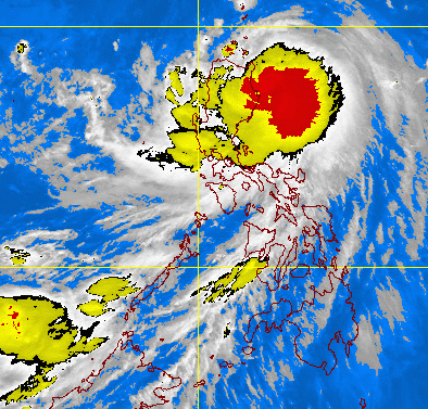
Image: DOST-PAGASA MTSAT-EIR Satellite Image for 9 a.m., 03 Oct. 2009
Typhoon Pepeng (Parma) has accelerated as it continues to move towards Cagayan. According to PAGASA, as of 4:00AM, the typhoon's center was located 260 km Southeast of Aparri, Cagayan. It has now a maximum sustained winds of 175 kph near center and gustiness of up to 210 kph.
Typhoon Pepeng is expected to make landfall over Northern Cagayan on Saturday evening. On Sunday morning, it is expected to be 150 kms Southwest of Basco, Batanes and on Monday morning, at 290 kms West Northwest of Basco, Batanes.
Areas having Public Storm Warning Signal:
Signal No. 3 (100-185 kph winds) - Cagayan, Babuyan Island, Calayan Island, Northern Isabela
Signal No. 2 (60-100 kph winds) - Batanes Group, Apayao, Kalinga, Ilocos Norte, Abra, Mt. Province, Ifugao, Quirino, Nueva Vizcaya, Rest of Isabela, Northern Aurora, Polilio Island, Catanduanes
Signal No. 1 (30-60 kph winds) - Ilocos Sur, Benguet, La Union, Pangasinan, Nueva Ecija, Bulacan, Rizal, Rest of Aurora, Quezon, Camarines Norte, Camarines Sur, Albay
Residents in low-lying areas and near mountain slopes under signals #3, #2 and #1 are advised to take all the necessary precautionary measures against possible flashfloods and landslides. Those living along the coast in areas under signal #2 and #3 are advised to be alert against big waves generated by the typhoon.
According to reports, Laguna de Bay's water level continue to rise. Also, Marikina River had reached its critical water level and residents leaving nearby were advised to evacuate the place. The Provident Village in Marikina City that hadn't yet recovered is now flooding again with water level continue rising.
Update: 10/03/09 11:30AM

Typhoon Pepeng (Parma) continues to move Northwest at 17 kph towards Cagayan.
As of 11:00 AM, the typhoon's center was located 150 km Southeast of Aparri, Cagayan or 100 km East of Tuguegarao City.
Typhoon Pepeng has maximum sustained winds of 175 kph near center and gustiness of up to 210 kph.
As PAGASA forecasted, typhoon Pepeng is expected to make landfall over Northern Cagayan on Saturday evening. On Sunday morning, it is expected to be 70 kms Northwest of Aparri, Cagayan or 50 kms South Southwest of Calayan Island; on Monday morning, at 120 kms West of Basco, Batanes and on Tuesday morning at 200 kms North Northwest of Basco, Batanes.
Areas in Luzon having Public Storm Warning Signal:
Signal No. 3 (100-185 kph winds) - Batanes group of Island, Cagayan, Babuyan Island, Calayan Island, Ilocos Norte, Abra, Apayao, Kalinga, Northern Isabela
Signal No. 2 (60-100 kph winds) - Rest of Isabela, Ilocos Sur, Mt. Province, Ifugao
Signal No. 1 (30-60 kph winds) - La Union, Benguet, Nueva Vizcaya, Quirino, Aurora, Nueva Ecija, Eastern Pangasinan
Public Storm signals elsewhere are now lowered.


